Hiking the Volcanic Trails of Tenerife
Some links in this guide are affiliate links — if you book through them we may earn a small commission at no extra cost to you. It never changes what we recommend. Full disclosure.
Most visitors think of Tenerife as a sun-drenched escape, a place for golden beaches and ocean dips, but they often overlook the island’s raw, dramatic heart. The truth is, Tenerife’s real magic lies in its astonishing volcanic landscapes, offering some of the most unique experiences for hiking volcanic trails Tenerife has to offer. While many assume it’s just about Teide, the reality is a diverse network of paths cutting through ancient laurel forests, moon-like craters, and coastal cliffs, each telling a distinct geological story. This guide will walk you through everything you need to know to move beyond the poolside and truly connect with Tenerife’s fiery soul.
Quick Answer: Hiking Tenerife’s Volcanic Trails
Absolutely, hiking Tenerife’s volcanic trails is profoundly worth it, offering an unparalleled journey through diverse and dramatic landscapes ranging from the lunar plains of Teide National Park to the ancient, mist-shrouded laurel forests of Anaga. You need to prepare adequately for varying altitudes and microclimates, but the rewards are views and experiences unlike almost anywhere else in Spain.
Conquering the Giant: Teide National Park Trails
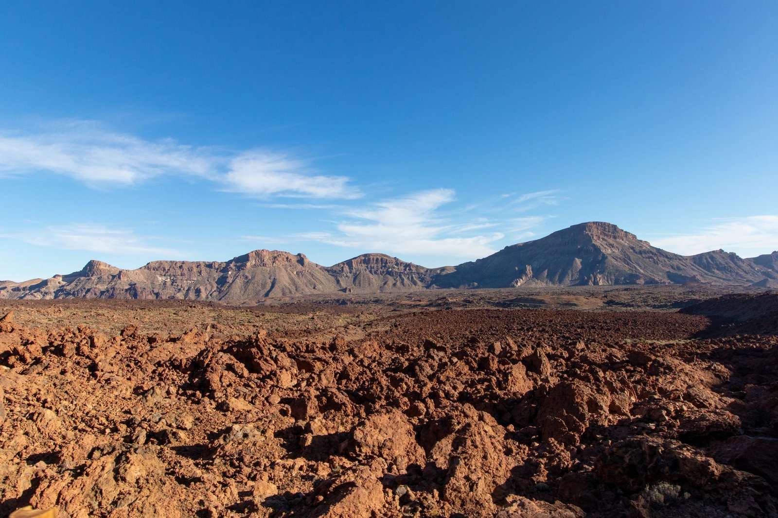
Teide National Park isn’t just a highlight of Tenerife; it’s a monumental landscape that demands your attention. The sheer scale and otherworldliness of this place truly needs to be experienced on foot. While the peak of Teide itself is the ultimate goal for many, the surrounding trails offer incredible access to this UNESCO World Heritage site without needing to reach the summit. The park entrance is free, and it’s open 24/7, though specific trails and facilities have their own operating hours.
The Ascent to Pico del Teide
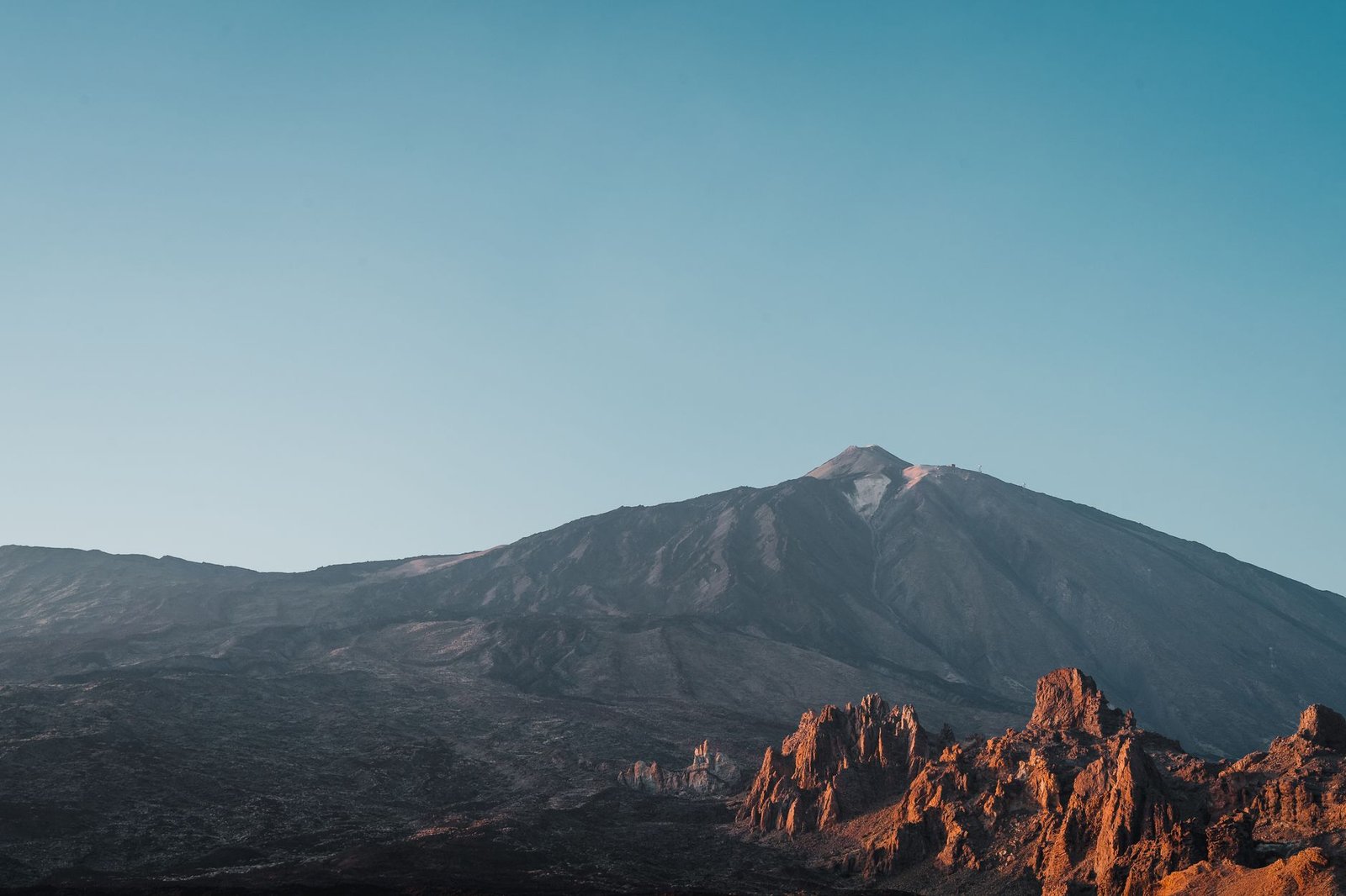
Reaching the 3,718-meter summit of Pico del Teide is a bucket-list achievement, but it requires planning. You absolutely need a permit from the Teide National Park office (online) to hike the final stretch from the top of the cable car to the peak. These permits are free but are released in limited numbers months in advance and disappear very quickly. Check the official park website for availability and book as soon as your travel dates are firm. If you don’t secure a permit, your options are limited to either joining a guided tour that includes permits (often booked out months ahead too) or hiking only to the cable car upper station (La Rambleta) at 3,555 meters, which does not require a permit. The Teide Cable Car operates daily from 9:00 to 16:00 (last ascent at 16:00, last descent at 17:00), costing €22 for a one-way ticket or €40 return for non-residents. Be prepared for queues, especially in peak season. Also, be aware that the cable car closes if wind conditions are too strong, and this can happen even on otherwise sunny days, so always check their website on the morning of your planned visit.
Roques de García Trail
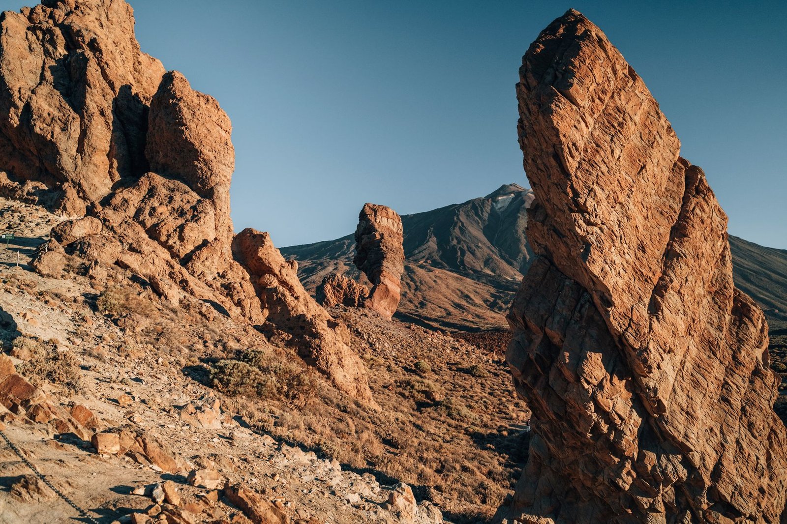
For a taste of Teide’s unique geology without the need for permits or extreme exertion, the Roques de García trail is an excellent choice. This is a circular route, about 3.5 kilometers long, taking around 1.5 to 2 hours. It’s a relatively easy walk with minimal elevation gain, suitable for most fitness levels. You’ll wind around towering rock formations like “El Roque Cinchado,” which often features in photographs of Teide. The trail starts directly opposite the Parador Nacional de las Cañadas del Teide, where there’s also a small visitor center and a café if you need a refuel. Go early in the morning, around 8:30 or 9:00, or late afternoon, to avoid the biggest crowds and the harsher midday sun. The landscape here truly feels like another planet, with strange, sculpted rocks formed by erosion over millennia. You’ll find similar challenges and rewards exploring the unique landscapes of the Wander the El Torcal Antequera hiking trails, Spain’s stone garden, though the geology is vastly different.
Siete Cañadas Trail
If you’re looking for a longer, more immersive experience in the caldera, the Siete Cañadas trail is a fantastic option. This linear trail (sendero 19) is much less trodden than the Roques de García, stretching about 16 kilometers and taking around 5-6 hours. It runs along the base of the caldera wall, offering expansive views of Teide and Pico Viejo. It’s a moderately difficult hike, primarily due to its length and exposure to the sun, with a cumulative elevation gain of around 400 meters. The trailhead is near the El Portillo Visitor Centre, and it ends near the Parador. You’ll need to arrange transport for the return journey unless you’re up for hiking back, which would make for a very long day. Pack plenty of water – there are no services on the trail – and be prepared for dramatic shifts in temperature between sun and shade. The quiet here is profound, letting you truly appreciate the scale of the landscape. Remember that temperatures can drop sharply at altitude, even in summer, so layers are non-negotiable.
Lush Volcanic Beauty: The Anaga Rural Park
Moving from Teide’s arid, high-altitude desert to Anaga Rural Park feels like stepping into another world entirely. Located in the northeast of Tenerife, Anaga is characterized by deep ravines, jagged peaks, and the most extensive laurel forest on the Canary Islands – a relic from the Tertiary period. This area is much wetter and greener than Teide, offering a completely different hiking experience with misty trails and ancient trees. The park is free to enter, and its trails are accessible year-round, though some visitor centers have specific hours.
Path of the Senses (Sendero de los Sentidos)
For an easy introduction to Anaga’s unique ecosystem, the Path of the Senses (Sendero de los Sentidos) is ideal. It’s located near the Cruz del Carmen Visitor Centre, which is also a great place to pick up maps and information (open daily from 9:30 to 16:00). There are three distinct routes, all starting from the same point:
- Route 1 (Short): 340 meters, about 10-15 minutes. Fully accessible, designed for sensory engagement with plaques to touch, smell, and listen to. Perfect for families or those with limited mobility.
- Route 2 (Medium): 530 meters, about 20 minutes. A slightly longer version of Route 1, still easy.
- Route 3 (Long): 1.2 kilometers, about 30-45 minutes. Takes you deeper into the forest, offering a more immersive experience with gentle slopes.
These paths are well-maintained and provide an excellent introduction to the cloud forest’s biodiversity. The air is often cool and damp, and the trees are draped in moss and ferns, creating an almost enchanted atmosphere. It’s a stark contrast to Teide, showcasing Tenerife’s incredible ecological diversity.
Vueltas de Taganana Circular Trail
For a more challenging and rewarding hike, consider the Vueltas de Taganana circular trail (Sendero PR-TF 4). This route is approximately 8.5 kilometers long and takes around 3-4 hours, with significant elevation changes (about 600 meters). It starts and ends in the picturesque village of Taganana, one of Anaga’s oldest settlements. The trail descends through laurel forests, offering glimpses of traditional farming terraces, before reaching the coast. You’ll experience stunning views of the rugged coastline and the Atlantic, sometimes even spotting the unique Anaga dragon trees. The return leg involves a steep climb back up to Taganana. This hike requires sturdy footwear and a reasonable level of fitness. The reward is experiencing the full spectrum of Anaga’s landscape, from dense forest to dramatic cliffs. There are a couple of small, local restaurants in Taganana where you can enjoy a hearty meal after your hike, often serving fresh fish and traditional Canarian dishes.
Essential Gear and Staying Safe on the Trails
Preparation is key for any hike, but especially when dealing with volcanic terrain and unpredictable mountain weather. For those looking for something less strenuous but equally rewarding, consider the Easy hiking Alpujarras beginner trails, but don’t underestimate the Canarian challenges.
Gear Checklist
No matter which trail you choose, having the right equipment will make your experience safer and more enjoyable. Here’s a breakdown:
| Item | Why You Need It | Approx. Cost (EUR) |
|---|---|---|
| Sturdy Hiking Boots | Volcanic rock is uneven and abrasive; ankle support is crucial. | 80-150 |
| Layers of Clothing | Temperatures can change drastically – warm fleece, waterproof jacket. | 50-100 (for essential layers) |
| Backpack (20-30L) | To carry water, food, extra layers, and essentials. | 30-70 |
| Water (2-3 liters/person) | Especially vital in Teide; dehydration is a real risk. | ~2-5 (for bottled water) |
| Sun Protection | Hat, sunglasses, high SPF sunscreen – altitude intensifies sun. | 15-30 |
| Snacks/Energy Bars | Keep your energy up, especially on longer trails. | 5-15 |
| First-Aid Kit | Blister plasters, antiseptic wipes, pain relievers. | 10-25 |
| Map & Compass/GPS App | While trails are often marked, technology can fail. | Free (app) – 20 (map) |
| Headlamp/Flashlight | If starting before dawn for sunrise or hiking near dusk. | 10-25 |
Safety Considerations
- Altitude Sickness (Teide): If you plan to hike above 2,500 meters, be aware of the symptoms: headache, nausea, dizziness. Acclimatize by spending a day at a lower altitude, and ascend slowly. If symptoms worsen, descend immediately.
- Weather Changes: Tenerife’s microclimates mean one part of the island can be sunny while another is shrouded in cloud or rain. Always check the forecast for the specific area you plan to hike. In Teide, temperatures can drop below freezing even in summer, and strong winds are common. In Anaga, fog can roll in quickly, reducing visibility.
- Trail Conditions: Volcanic rock can be loose, especially on steeper ascents or descents. Be mindful of your footing. Anaga trails can be slippery when wet due to moss and damp earth.
- Emergency Numbers: The general emergency number in Spain is 112. Save it to your phone. Ensure your phone is fully charged before you start.
- Leave No Trace: Pack out everything you pack in. Stick to marked trails to protect the fragile ecosystems.
Logistics: Getting There and Where to Base Yourself
Effective planning for transport and accommodation can significantly enhance your hiking trip in Tenerife. While buses serve some areas, a rental car offers unparalleled flexibility and is highly recommended for exploring the diverse trailheads across Teide and Anaga.
Transportation
Rental Car: This is by far the most convenient option. You can pick up a car directly from Tenerife South (TFS) or Tenerife North (TFN) airports. Prices vary widely depending on the season, but expect to pay anywhere from €25-€50 per day for a compact car, excluding fuel. This gives you the freedom to reach remote trailheads at your own pace, carry all your gear, and stop for impromptu views. Driving in Tenerife is generally easy, though mountain roads in Anaga can be winding and narrow.
Public Transport (Bus): The Titsa bus network covers most of the island, but service to Teide National Park and some Anaga trailheads is limited. For Teide, bus line 342 runs from Costa Adeje and Los Cristianos, and line 348 runs from Puerto de la Cruz. Both routes depart once in the morning (around 9:15) and return once in the afternoon (around 16:00). A single ticket from Puerto de la Cruz to Teide cable car station costs around €6. For Anaga, buses connect Santa Cruz de Tenerife and La Laguna to towns like Cruz del Carmen and Taganana, but schedules can be infrequent, especially on weekends. Always check the latest Titsa schedules online well in advance, as relying solely on buses can significantly restrict your hiking options and flexibility.
Where to Base Yourself
Your choice of accommodation location can impact your daily logistics, particularly for early starts or late finishes on the trails.
- For Teide National Park:
- Vilaflor: At 1,400 meters, Vilaflor is the highest village in Spain and a fantastic base for Teide. It offers a few hotels and rural houses, allowing for better acclimatization if you’re sensitive to altitude. It’s about a 30-40 minute drive to the Teide cable car.
- La Orotava: Located on the north side of the island, this historic town offers more amenities and is a beautiful place to stay. It’s about a 45-60 minute drive to Teide, offering a scenic ascent.
- Parador Nacional de las Cañadas del Teide: The only hotel actually within the national park. Staying here allows for direct access to trails and incredible stargazing. It’s often booked solid months in advance and can be pricey, but if your budget allows, it’s an experience in itself.
- For Anaga Rural Park:
- Santa Cruz de Tenerife: The island’s capital offers the widest range of hotels, restaurants, and amenities. It’s about a 20-30 minute drive to the main Anaga trailheads like Cruz del Carmen. This is a practical base for exploring both Anaga and the city itself. You can compare hotel prices on Booking.com here.
- San Cristóbal de La Laguna: A UNESCO World Heritage city, La Laguna is another excellent choice. It’s slightly closer to Anaga than Santa Cruz and has a university-town vibe with lively squares and historic architecture.
- Rural Houses in Anaga: For a more immersive experience, consider renting a rural house (casa rural) in one of Anaga’s smaller villages like Taganana or Chinamada. These offer a genuine taste of local life but with fewer amenities.
Beyond the Main Paths: Other Volcanic Adventures and Tips
Tenerife’s volcanic landscape isn’t just about Teide and Anaga, though they are undoubtedly the stars. There are other fascinating areas where you can experience the island’s fiery past and unique geology. Exploring these can add another layer to your hiking adventure.
Malpaís de Güímar and Montaña Grande
On the southeastern coast, near the town of Güímar, lies the Malpaís de Güímar Special Natural Reserve. This area features a relatively recent lava flow (around 10,000 years ago) that created a rugged, desolate landscape of black rock, small cones, and lava tunnels. The circular trail around Montaña Grande, the main volcanic cone, is about 5 kilometers and takes around 2 hours. It’s an easy to moderate hike, offering great views of the coast and the bizarre, barren terrain. Access is free, and there’s a small visitor center nearby. This area is less crowded than Teide or Anaga and offers a different perspective on volcanic activity, right down to the sea.
Chinyero Volcano Natural Monument
For a walk through more recent volcanic history, head to the Chinyero Volcano Natural Monument in the northwest. This is the site of Tenerife’s last volcanic eruption in 1909. The circular trail around the Chinyero cone is about 6 kilometers long and takes around 2 hours. It’s a relatively easy and flat walk through pine forests and black lava fields, where life is slowly recolonizing the stark landscape. You can clearly see the different lava flows and the raw power of nature. The trailhead is accessible from the TF-38 road. It’s a humbling experience to walk where the earth last burst open and to see the resilience of the surrounding flora.
Best Time to Hike and Tour Options
The best time of year for hiking in Tenerife is generally spring (March to May) and autumn (September to November). During these seasons, the weather is typically mild, with fewer crowds than in peak summer or winter. Spring brings wildflowers to Teide and lush greenery to Anaga, while autumn offers comfortable temperatures. Summer can be very hot, especially in Teide, making early morning starts essential. Winter hiking is possible, but Teide can see snow and ice, and Anaga can be very wet and foggy.
If you prefer not to plan all the logistics yourself, consider booking a guided tour. A knowledgeable local guide can provide fascinating insights into the geology, flora, and fauna, as well as ensure your safety. There are many options available, from full-day Teide excursions to shorter Anaga forest walks. You can book a guided tour on Viator to find an experience that suits your interests and fitness level. Just as you discover the raw beauty of the Canaries on foot, remember there are other incredible island experiences like finding My favorite Mallorca secret coves to visit, year after year, each offering a distinct Spanish adventure.
FAQ: My favorite adventure – Common Questions
Do I need a permit to hike Teide?
You only need a permit if you plan to hike the final 400 meters to the very summit of Pico del Teide (trail no. 10) from the cable car’s upper station (La Rambleta). Permits are free but strictly limited and must be booked online, usually several months in advance, through the Teide National Park website. You do not need a permit to take the cable car to La Rambleta or to hike any other trails within Teide National Park, such as Roques de García or Siete Cañadas.
What’s the difference between Teide and Anaga hikes?
The difference is stark. Teide National Park offers high-altitude, arid, lunar-like landscapes with volcanic cones, lava fields, and sparse vegetation, often feeling like walking on Mars. Anaga Rural Park, in contrast, is characterized by ancient, misty laurel forests, deep ravines, and rugged coastlines, offering lush greenery, a cooler climate, and a feeling of stepping back in time to a prehistoric ecosystem. Each offers a completely unique volcanic hiking experience.
Is hiking in Tenerife suitable for beginners?
Yes, Tenerife has a wide range of trails suitable for all fitness levels, including beginners. The Path of the Senses in Anaga and the Roques de García trail in Teide are excellent, easy options. Many other trails are well-marked and have gentle gradients. However, some routes, particularly those involving significant elevation changes in Anaga or the full ascent of Teide, require a good level of fitness and proper preparation. Always check the trail difficulty before you set out.
What should I pack for a day hike in Tenerife?
For any day hike, essential items include sturdy hiking boots with good ankle support, layered clothing (including a waterproof jacket, even if the forecast is clear), a backpack with at least 2-3 liters of water per person, high SPF sunscreen, a hat, and sunglasses. Snacks, a basic first-aid kit, a map or GPS app, and a fully charged phone are also highly recommended. For Teide, consider warmer layers even in summer, and for Anaga, anticipate potential fog and dampness.
Tenerife offers more than just resort holidays; it’s an island where the very earth tells a story, carved by fire and time. Embracing the opportunity to hike its volcanic trails, whether in the ethereal Anaga forests or the dramatic lunar landscape of Teide, allows you to truly understand the island’s unique spirit. It’s a genuine adventure, one that gets under your skin and shows you a side of Spain you simply won’t find anywhere else.
About the Author
After 15 years living and traveling across Spain, Caro knows this country in a way most travel writers never will. She’s not here to sell you a polished version of Spain, she’s here to show you the real one. Every guide on this site comes from her own experience: the restaurants she eats at, the routes she walks, the festivals she’s actually attended. She writes to cut through the noise and give you what actually matters. Learn more about Caro →